
|
| |
A tour of old Nottingham - the English borough
This is a short photographic tour of Nottingham, from the Lace Market
down to the Castle. We begin with the English borough on St Mary's Hill.
|
The Lace Market
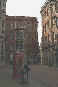 The old Saxon borough of Nottingham
originally grew up on the sandstone hill where St Mary's Church was later to be built. In
the ninth century, the Danes and the Vikings overran Mercia and Nottingham became part of
the Danelaw. After the Norman Conquest a new French community grew up around the Castle
which had been built a little to the west, and Nottingham soon became a town of two
boroughs, each with their own law courts and officials. (Two sheriffs were still being
elected until as recently as 1835.) The English borough was fortunate to be largely left
in peace, around its church of St Mary's. In the early nineteenth century, Nottingham
developed into the largest lace-making centre in the world and enjoyed a period of
prosperity. Many factories were built on St Mary's Hill to replace the grand town houses
which had stood there, and the area became known as "The Lace Market". The old Saxon borough of Nottingham
originally grew up on the sandstone hill where St Mary's Church was later to be built. In
the ninth century, the Danes and the Vikings overran Mercia and Nottingham became part of
the Danelaw. After the Norman Conquest a new French community grew up around the Castle
which had been built a little to the west, and Nottingham soon became a town of two
boroughs, each with their own law courts and officials. (Two sheriffs were still being
elected until as recently as 1835.) The English borough was fortunate to be largely left
in peace, around its church of St Mary's. In the early nineteenth century, Nottingham
developed into the largest lace-making centre in the world and enjoyed a period of
prosperity. Many factories were built on St Mary's Hill to replace the grand town houses
which had stood there, and the area became known as "The Lace Market".
|
|
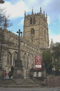 One of the three medieval churches of Nottingham,
situated in the middle of the Lace Market area. It was founded in Saxon times, rebuilt in
1175, and then completely rebuilt between 1375 (in the reign of Richard II) and 1475 -
with a noble tower, splendid stone vaulting, and huge windows in a grand Perpendicular
style to match the prosperity and confidence of that age. Inside are many fine tombs and
wall memorials, and often exhibitions of works of art. It is the largest church in the
city, and has long been the venue for civic occasions. Music is taken very seriously -
there is a modern Marcussen organ dramatically displayed in the transept, and the choir is
of a high standard. One of the three medieval churches of Nottingham,
situated in the middle of the Lace Market area. It was founded in Saxon times, rebuilt in
1175, and then completely rebuilt between 1375 (in the reign of Richard II) and 1475 -
with a noble tower, splendid stone vaulting, and huge windows in a grand Perpendicular
style to match the prosperity and confidence of that age. Inside are many fine tombs and
wall memorials, and often exhibitions of works of art. It is the largest church in the
city, and has long been the venue for civic occasions. Music is taken very seriously -
there is a modern Marcussen organ dramatically displayed in the transept, and the choir is
of a high standard.
Link to longer article about St Mary's
Link
to St Mary's
Church website |
High Pavement
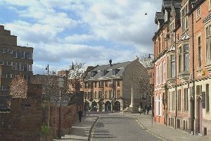 High Pavement was one of
the three medieval streets of Nottingham that were cobbled, the other two being (not
surprisingly) Middle Pavement and Low Pavement, at a time when most streets were simply
mud tracks. During the eighteenth and nineteenth centuries many gracious residential
properties were built on High Pavement and it became "an enchanting seat in the heart
of the town". The picture shows the view looking away from St Mary's Church towards
Weekday Cross and Middle Pavement, leading down to the French borough. The Cross was the
site of a market from Saxon times onwards. On the left can be seen part of the Broadmarsh
Centre, a memorial to the late sixties and early seventies when several fine old
Nottingham buildings were demolished and the medieval street pattern completely disrupted
by Maid Marian Way. The old medieval thoroughfare of Drury Hill was also destroyed during
the construction of the Broadmarsh Centre, and only the activities of the
Nottingham Hidden History Team
helped to prevent many of the caves below the Centre from being irrevocably damaged. High Pavement was one of
the three medieval streets of Nottingham that were cobbled, the other two being (not
surprisingly) Middle Pavement and Low Pavement, at a time when most streets were simply
mud tracks. During the eighteenth and nineteenth centuries many gracious residential
properties were built on High Pavement and it became "an enchanting seat in the heart
of the town". The picture shows the view looking away from St Mary's Church towards
Weekday Cross and Middle Pavement, leading down to the French borough. The Cross was the
site of a market from Saxon times onwards. On the left can be seen part of the Broadmarsh
Centre, a memorial to the late sixties and early seventies when several fine old
Nottingham buildings were demolished and the medieval street pattern completely disrupted
by Maid Marian Way. The old medieval thoroughfare of Drury Hill was also destroyed during
the construction of the Broadmarsh Centre, and only the activities of the
Nottingham Hidden History Team
helped to prevent many of the caves below the Centre from being irrevocably damaged.
|
Link to the French borough
Return to the Guides
contents page
|